 |
This article is Under Construction and as such may be considered incomplete. Information appearing on this page is as accurate as possible but further work is intended before the page will be considered mature and this notice removed.
|
|
| HMCS Coverdale
|
|---|
|
|
HMCS Coverdale Crest
|
It's not known specifically when Coverdale was opened, however it is believed to have initially begun its role in the RCN as an HFDF site as early as 1941. The Coverdale station was located approximately three miles from Moncton New Brunswick, on the opposite side of the Petitcodiac River. Reports indicate that a HFDF site opened in 1941 contributing to Allied ASW operations in the Atlantic during the Second World War. Initially it was staffed by WRCNS, but as part of the Navy's self-reliant plans, new buildings "Y" and HFDF activities were constructed sometime in 1943 with operations commencing in 1944. After the war the station continued to provide HFDF support for SAR purposes in addition to maintaining a small nucleus of trained operators. With the post war slump ending on the decision for Communications Research, Coverdale's potential value was once again appreciated. Gradual enlargement of the operational scope and physical facilities took place. In 1949 the station was commissioned as HMCS COVERDALE. The station continued to provide support to anti-sub activity, SAR activity and maintain research facilities in support of the Communications Research of NRC. In 1950 the RCN and the United States Navy (USN) agreed to coordinate and standardize direction-finding activities for search and rescue operations in the Atlantic. Coverdale, along with her sister station at NRS Gander became members of the CANUS Atlantic High Frequency Direction Finding Network. Coverdale would eventually be closed July 1971 as part of the Beagle project.[1]
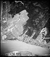 1950 aerial view of Coverdale |
The PMQs are the buildings that make an 'L' shape just left of centre in the photo.
|
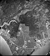 1959 aerial view of Coverdale |
The PMQs are more built up in this photo although the area around the DF shack looks about the same.
|
References
- ↑ Note: The above description was extracted from the history of Canadian CESM found on this site.


